Relic point Vietnam
Việt Nam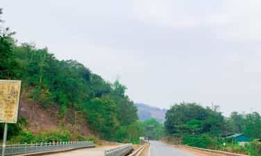
Ta Vai Bridge
Ta Vai Bridge, located in Ta Vai village, Chieng Hac commune, Yen Chau district, is a famous historical relic of the province. During the resistance war against the French colonialists, the bridge not only had a meaning for people's livelihood but was also a historical relic. Ta Vai village has a bridge with 46 fierce attacks and suffered 1,272 bombs from American aircraft to cut off the main artery of Highway 6. But the bridge still stands, ensuring smooth traffic. In 1965, the American enemy used air force and commandos to frantically sabotage the North in order to prevent the North from providing support to the Southern people. On June 20, 1965, American planes dropped 6 bombs on Khau Day village (Chieng Hac, Yen Chau) and 20 rockets on Ta Vai bridge. . Starting from here, American aircraft continuously bombarded Yen Chau, but due to good preparation of plans to deal with America's destructive war, Yen Chau entered the war without being surprised. At this time, Ta Vai bridge became a place of fierce fighting between us and the enemy. With the determination to ensure smooth traffic flow in all situations, determined to stay at the traffic center of Ta Vai bridge, the militia and self-defense force and armed force units have always stuck to the road and bridge to ensure traffic is clear. Here, from March to December 1966, we arranged the 14th Battalion of anti-aircraft artillery to protect the Ta Vai bridge, in which Company 3, consisting of two 37mm artillery batteries, was positioned in the area of Ban Tat hill. , adjacent to Tai Vai bridge, Company 2, consisting of four 37mm guns, was arranged in a continuous position to the west of Ta Vai bridge. In addition to the two main battlefields with 37 mm cannons, there is also a secondary battlefield consisting of a 12.7 mm company located in lower terrain also near Ta Vai bridge. To arrange such a battlefield, the people of Ta Vai village and the soldiers dug fortifications to build a road around the hillside to pull up artillery. Each 37 mm cannon required 200 people to pull it. To encourage morale and help soldiers fight, the people of Ta Vai village enthusiastically participated in the fighting and produced rice to contribute to the front lines. During those years, the people of Ta Vai, along with other villages in Chieng Hac commune, contributed nearly 9 tons of vegetables, 500kg of poultry, tons of food... In addition, the commune's performance team also went to the battlefield in uniform. army and militia service. Many times having to move the battlefield, the people and the soldiers used forest rope to braid to pull the artillery; used bamboo to make shacks for the soldiers and helped the soldiers dig over 3,000 meters of shelters on the battlefield with the determination to protect the transportation artery for the battlefield. The enemy destroyed bridges and roads, but the spirit of the army and people here was undeterred. Despite the roar of bombs and bullets, they still enthusiastically repaired the roads for vehicles to pass, with the emulation movement "Singing over the sound of bombs" and "Singing over the sound of bombs" and "Singing over the sound of bombs" The enemy broke it, I'll fix it. If the enemy destroys me, let me go." On December 8, 1966, the enemy organized 3 groups of planes to drop bombs on the hill where there was an anti-aircraft artillery battlefield and bombarded the Ta Vai bridge. At this time, 2 bridge spans were hit by bombs and fell into the stream and traffic on Route 6. was cut. Because the bridge was in a dangerous location, the stream was wide, the water was deep, and the enemy fought day and night, so it was very difficult to rebuild the bridge. Faced with that situation, the bridge protection unit decided to build a bypass and underground road to ensure traffic at all costs. The underground tunnel of Ta Vai bridge was built by soldiers and civilians about 1km downstream, but the enemy still discovered it and continued to bombard it. With courageous fighting spirit, the army and militia units have well secured traffic arteries. Promoting the tradition of tenacious fighting and the spirit of solidarity, the people of Ta Vai village with a boiling spirit of hatred for the invaders turned into revolutionary actions in combat and production, making an outstanding contribution to the achievements in defeating the US imperialist plot to expand the war. At the Ta Vai battlefield, the army and people of Yen Chau shot down 2 F105 planes and captured American enemy pilots with rifles, the lifeline of support for the South was always running smoothly, that victory quickly spread throughout the world. place, known throughout the country. Today, the war has receded into the past, the people of Ta Vai work hard in production and continue to contribute human and material resources to their homeland, where the Ta Vai bridge marks the crimes of American imperialism during the war. war of invasion in Vietnam. Talking about Ta Vai bridge is talking about the heroic, resilient fighting spirit and glorious fighting of Yen Chau's army and people. Source: Son La province electronic information portal
Son La
8499 view
Rating : Provincial level relics

A Phu Cave
Tham Can Cave, also known as the "A Phu Couple" cave, was the 99th revolutionary base during the resistance war against the French in Son La province. The cave belongs to Hong Ngai commune, Bac Yen district, Son La province. The relic includes two caves: The first cave (dry cave) is located at the foot of U Bo mountain, surrounded by primeval forest, with a cool, airy climate. In front of the cave is the people's fields, covered in all four seasons with green flowers and fruits. The dry cave consists of 2 doors located on the East and West sides, connected to each other, dividing the cave into 3 compartments. The total length of the cave from West to East is about 200m. The western door is about 3m high, 1.5m wide, the entrance to the cave is small and narrow, limiting light. The deeper you go, the more the cave expands, with an average ceiling height of 20 to 40 meters and an average width of 15 to 30 meters. The cave floor is rough and slightly sloping, with many rocks scattered all over the cave floor. The ceiling of the cave has many beautiful stalactites shaped like animals, forests, etc. In the second and third chambers, there are also many narrow niches running along the cave walls, on average 10 to 15 meters deep. Go through compartment 3 to reach the east door. The oval cave entrance is about 50 to 60 meters high, about 20 meters wide at the bottom, and about 30 meters wide in the middle. This is where the Military Intelligence Company of the General Staff temporarily stayed for two days to find a way to cross the Da River to prepare for the 1952 Northwest campaign. According to local people, Tham Biet cave was also the place where soldiers and soldiers were stationed. storing weapons of our army and people in the resistance war against American invasion. In addition, Tham Bien cave is also known in literature as A Phu Couple Cave. According to legend, after escaping from Governor Pa Tra's family to reach the Phieng Sa guerrilla area, My and A Phu (the two main characters in the work) stopped here for a while to avoid being searched by the bandits. Governor. The second cave is a water cave about 20 meters south of the first cave. The entrance to the cave is about 5 meters deep underground. The road down to the cave is steep, has many bumpy rocks, and is very dangerous. The cave is about 300 meters long. The cave is dark, about 7 meters wide, from the cave floor to the ceiling is on average about 10 to 12 meters high, in some places it is only 4 to 5 meters high. The cave floor is a stream flowing along the cave from West to East. This is where the Military Intelligence Company came to get water for daily use during their temporary stay in the dry cave. Tham Can Cave - Resistance Base Area 99 was ranked as a Provincial Historical Monument on May 28, 2012. Source: Electronic information portal of Bac Yen district, Son La province
Son La
6218 view
Rating : Provincial level relics
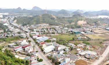
Historical relic of Na San stronghold group
The Na San stronghold group is located on the Na San plateau, a basin in Chieng Mun commune - Mai Son district - Son La province with an area of about 10km2 surrounded by mountains over 700m high. There is an airport, a command post, a number of posts, a strong firepower system of four 105mm guns and many trenches surrounding the central area. Like the Dien Bien Phu base group, the most important part of this military base is Na San airport, which is responsible for supplying French troops on duty here. This airport was built in 1950 when the French army dominated and oppressed the people of the Northwest ethnic groups after taking control from the Viet Minh. Initially, Na San airport served the needs of travel with a short, small runway system and simple structure. It was later expanded, lengthened and upgraded with iron grate flooring, able to meet all types of traffic. Dakota planes take off and land. For nearly a month since the French army withdrew here, they have continuously reinforced food, weapons, ammunition, barbed wire and other necessary materials to reinforce this military base. . Because time was tight, the fortification system here was quickly made with rudimentary materials such as bamboo, wood, etc. and was temporarily built and covered for living and fighting. At the bases in the central area and around the airport, priority is given to being solidly built with cement, sand, and paved with iron sheets. The central command tunnel also has a relatively safe trench system to escape to the airport in case of need. The Northwest Campaign began on October 1, 1952 and ended on December 10, 1952. After 3 fierce attacks by our army and people, the campaign quickly ended 4 months earlier than the original estimate. We destroyed many enemy troops and captured many weapons and ammunition. The enemy had to withdraw to cluster at the Na San stronghold group. Faced with a completely passive and isolated situation, they knew they could not survive on this land, so they secretly fled by air from Na San airport. The Northwest Campaign ended in complete victory. Up to now, little is known about the Na San stronghold group because of its small scale and passive nature of response. However, this was the first origin for the form of attacking a group of strongholds of the French colonialists, the idea of forming the Dien Bien Phu stronghold group later, and the first form of defense with strategic significance that appeared. present during the Vietnam War. The Na San stronghold group is evidence of the heroic years of our army and people fighting against the French colonialists in the Northwest battlefield, a mark of the disastrous defeat of the French colonialists. Na San stronghold group was ranked as a national historical relic on January 24, 1998. Source: Son La province electronic information portal
Son La
7567 view
Rating : National monument
Thuan Chau Flag Tower historical site
Thuan Chau Flag Tower historical site is located in Pan village, Chieng Ly commune, Thuan Chau district. This place marks a historic event on May 7, 1959, when President Ho Chi Minh together with the Party and Government leadership visited the Northwest. During the resistance war against the French and after peace was restored in the North, despite being busy with thousands of national affairs, Uncle Ho, the beloved Father of the nation, always cared about the people of the Northwest ethnic groups. Responding to Uncle Ho's trust, the people of the Northwest ethnic groups were courageous in fighting, enthusiastically emulating productive labor and wished to welcome Uncle Ho to visit and report to him on his achievements. On May 7, 1959, the wishes of the people of the Northwest peoples came true. The square of the capital of the Thai autonomous region, Meo, was resplendent with flags, flowers, banners and slogans and more than 10,000 people representing 430,000 people from the Northwest ethnic groups happily welcomed Uncle Ho leading the Party and Government delegation. cover the visit. With an extremely simple, intimate and close gesture, Uncle Ho recognized and praised the sacrifices and enormous contributions of the people of the Northwest ethnic groups in the resistance war against the French colonialists and in restoring the economy. economy after the war. On behalf of the Government, he presented the people of the Northwest ethnic groups with the first-class Labor Medal. He advised: We must enthusiastically compete for economic and social development, strengthen economic sectors, apply science and technology to production, develop education and healthcare networks, and strengthen national security. room. More than 40 years have passed, and his advice has been persistently strived to be implemented by the Party Committee, government and people of Son La ethnic groups, and has been making great changes in the Western region of the country. big. Today, the Thuan Chau flag tower historical relic is located right on the campus of Thuan Chau district stadium. Source: Son La province electronic information portal
Son La
8770 view
Rating : National monument
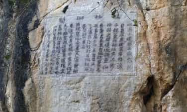
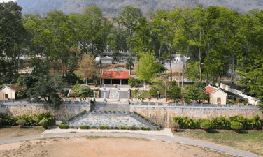
The Guilin Stele dominates
Que Lam Ngu Che stele historical relic belongs to group 3, Chieng Le ward, Son La city. This place demonstrates the historical period of the talented and great strategist Le Thai Tong and his soldiers conquering rebels in the western border region of the country, keeping peace for the country. The relic was ranked at the National level by the Ministry of Culture and Information on February 5, 1994. King Le Thai Tong, whose name is Nguyen Long, is the second son of King Le Thai To (Le Loi) and Queen Mother Pham Thi Ngoc Tran, a native of Quan Lai, Loi Duong district (now Tho Xuan - Thanh Hoa). ). Since ascending the throne, King Le Thai Tong has paid great attention to the Northwest region, the land of the country. To consolidate and ensure national unity, like King Le Thai To and other kings, during the 9 years of reigning the country, King Le Thai Tong twice commanded soldiers to go to the Northwest to suppress traitors. inverse. In March of the year Canh Than (1440), the king for the first time personally and with his soldiers went to the Western town to fight a rebel army named Thuong Nghiem in Chau Muong Muoi (now Thuan Chau district, Son La province). Wherever the king went, he was supported by the people, so the royal army quickly crushed the rebels. On the way back, the king and his soldiers stopped at Dong La (Tham Bao Ke), a natural rock cave in Muong La province. The king saw that this place had beautiful scenery, favorable geography, profound meaning and a peaceful soul. The king had his soldiers carve a poem and preface on the cliff at the entrance of Dong La. The poem, Guilin Ngu Che, has the following meaning: "The chief of Thuan Chau, Thuong Nghiem, rebelled, was ungrateful, and led his troops to follow the Ai Lao people to rebel. Personally commanded six armies to conquer it. Thuong Nghiem used all his strength and offered an elephant to surrender. I felt sorry for him for kneeling and crawling without a weapon, not having the heart to cut him, so I forgave him, then brought the army back and left a poem. Exactly one year later, in March 1441, the king again sent troops to suppress the Nghiem Nghiem rebellion in Chau Muong Muoi. Everywhere he went, the people responded and helped him, so the royal army quickly captured General Ai Lao. Dao Mong, at the same time captured Thuong Nghiem's children Sinh Tuong and Dong Dong. The traitor Thuong Nghiem surrendered and accepted the crime, from now on the western border of the Fatherland has been at peace. To pay tribute to the merits of King Le Thai Tong and to make the Que Lam Ngu Che stele monument forever dignified and shine in the hearts of successive generations, meeting the spiritual and healthy religious needs of a large number of people. people, with the consent of the Ministry of Culture and Information, in September 2001 the Provincial Party Committee and People's Committee of Son La started construction of the temple of King Le Thai Tong in Son La town and was inaugurated on September 22. January 2003, named "Guilin Ling Tu". Source: Son La province electronic information portal
Son La
8574 view
Rating : National monument
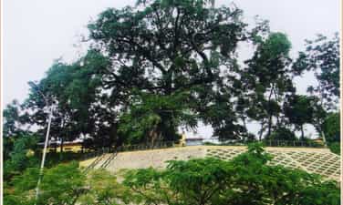
NAKED VERSION TREE
In the early twentieth century, the French colonialists established their governing apparatus in the Northwest region. They built Son La Prison to imprison, exile, and destroy the will to fight of revolutionary soldiers and patriotic Vietnamese people. In December 1939, political prisoners at the prison held a secret meeting and decided to establish a provisional cell. The cell chose the Heo banyan tree as a secret contact point with the revolutionary base outside the prison and with the Party Central Committee. In 1942 - 1943, the revolutionary situation in the country and the world was very volatile, the Party Central Committee directed the Yen Bai and Phu Tho base areas to establish a contact line with the Son La prison cell. Every day, political prisoners in Son La Prison had to go to the banyan tree area to get firewood, so the prisoners set up a secret mailbox to contact and assess the enemy situation, in order to organize an escape. According to the planned plan, in January 1943, Comrades at the Central Agency arranged to meet with comrades in Son La Prison Party Cell at Ban Heo banyan tree. Agree on the prison escape plan. With the careful preparation of prisoners from inside the prison to comrades and soldiers outside the prison, on August 3, 1943, the Cell successfully organized an escape for elite prisoners. returned to the Party Central Committee to continue revolutionary activities. Thus, during the period of struggle against the invading French colonialists, along with other communication locations, the Heo banyan tree was the place where the secret mailbox was located, and the meeting and communication place between communist soldiers of the Communist Party of Vietnam. The prison cell and the Central leadership - have really played an important role, contributing to creating a solid information network, covering the enemy's dense spy network, serving development. of the revolution and contributed greatly to the victory of the movement to gain power in Son La in particular and the country in general. The Heo banyan tree is now a revolutionary historical relic in the special national relic complex of Son La Prison, managed by the Provincial Museum. Every year, the monument welcomes hundreds of thousands of visitors to visit, learn and research. Even though it has gone through many ups and downs of history, the banyan tree is still there as a testament to a historical period of revolution in the twentieth century. Source: Son La Provincial Museum
Son La
8784 view
Rating : National monument
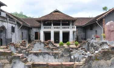
Son La Prison Relics
Son La Prison was built by the French colonialists in 1908, next to Nam La stream on top of Khau Ca hill, now in To Hieu ward, Son La city, Son La province. This place held 1,007 communist prisoners, was a revolutionary school, and where the "red seeds" of the Vietnamese revolution were nurtured. Son La Prison was built by the French colonialists in 1908 with an initial area of 500 m2, mainly to imprison common criminals. In 1930, as the Vietnamese revolution's struggle for national independence increased, the French colonialists expanded Son La Prison by 1,500 m2 and began to detain political prisoners. In 1940, the French colonialists built a prison camp with an area of 170 square meters with the intention of holding female prisoners, but this plot was not carried out. Thus, through 3 times of construction and expansion, Son La Prison has a total area of 2,170 m2. In particular, during the process of expanding the prison, the French colonialists also built a series of underground cells 3 meters deep underground, hidden by the kitchen area above. The underground cell system includes 5 individual cells and 2 collective cells, including 1 dark cell. Son La Prison is solidly built, with walls made of stone and brick, and a roof of corrugated iron. The beds for prisoners are built of stone, have a cement surface, and have a leg shackle system along the length of the floor on the outside. With such a design, the Laotian winds of the Northwest region with blazing heat in the summer and cold frosts in the winter have caused diseases to arise and spread quickly. Son La prison is likened to "an open coffin, just waiting for the prisoner to die and bury him". From 1930 to 1945, the French colonialists exiled to Son La Prison 14 groups of political prisoners with a total of 1,013 prisoners, including many comrades who were members of the Central Committee, Party Committee, City Party Committee and many others. core Party officials. Faced with the crimes of the enemy, more than ever, the spirit of the communists shone and lit the fire of revolutionary struggle throughout the Northwest mountains and forests, greatly contributing to the success of the General War. August Uprising in 1945. This place has become a great revolutionary school, training and fostering for the Party and the Vietnamese revolution outstanding and typical Communist soldiers such as: To Hieu, Le Duan, Truong Chinh, Nguyen Luong Bang, Van Tien Dung, Le Duc Tho, Nguyen Van Tran, Le Thanh Nghi, Tran Quoc Hoang and other faithful comrades. With peace restored, Son La Provincial Museum has renovated and embellished the Prison relic three times in 1980, 1994, 2009 - 2010. Son La Prison historical relic also has 2 points: Ban Heo banyan tree, the contact point between Son La Prison Cell and the Party Central Committee and Son La Prison Martyrs Cemetery (Guava Root Cemetery) is The resting place of more than 60 heroes and martyrs who sacrificed their lives at Son La Prison. The historical site of Son La Prison has become a red address in the work of educating revolutionary traditions for generations of ethnic groups in Son La and the people of the whole country. Son La Prison was ranked national in 1962 and a special national historical site on December 31, 2014. Son La Prison Relics has become a school, a center of revolutionary traditional education for generations of Vietnamese people, especially the younger generation. Source: Son La Province Electronic Information Portal
Son La
8896 view
Rating : Special national monument

Cannon road
The artillery track relic is located in Na Nhan commune, Dien Bien district, Dien Bien province, located along Highway 279 on the right bank of Nam Rom river in the direction from Tuan Giao to Dien Bien. This place marked the change in the combat motto of the Front Command from "fight quickly, win quickly" to the motto "fight firmly and advance firmly". And this is also a historical place imprinted with sacrifices, difficulties and hardships as well as solidarity and synergy during the preparation of the campaign, the spirit of determination to overcome all challenges and hardships to win. On January 14, 1954, at the Campaign Command Headquarters in Tham Pua Cave, Km 15, Tuan Giao - Dien Bien Street, the Party Committee and the Campaign Command met to discuss a plan to destroy the Dien Bien Phu stronghold group. The Politburo's strategic determination at the meeting was to concentrate forces to destroy all enemy troops in Dien Bien Phu according to the principle of "sure victory". The artillery towing command was established with comrade Le Trong Tan as commander and let each type of gun be tested to learn from experience and decided to use a truck to tow the artillery at kilometer 9 near Na Nhan village and stop cutting. The artillery got out of the vehicle and used human power to pull dozens of 3-ton artillery pieces into battlefields over a distance of 15km. The artillery road is 3m wide, running from the mouth of Na Nhan forest through the 1150m high Pu Pha Song peak, equivalent to a 40 - 60 degree slope down to Ban Tau, Dien Bien Phu - Lai Chau road to Nghiu village. To ensure secrecy, the artillery path must be completely camouflaged to prevent detection by reconnaissance aircraft. The estimated road construction time was one day and one night. The soldiers of the 308th Army, a company of mountain artillery, and an engineering battalion of more than 5,000 people successfully completed the road to pull the artillery in 20 hours. The next thing is to put howitzers and anti-aircraft guns into the battlefield position to fire. The mission was given to Group 351 and Group 312, expected to be completed in 3 nights. But after 7 arduous days and nights, our artillery still did not reach all the battlefields compared to the original plan, so the planned shooting time of January 20, 1954 had to be postponed for 5 days, i.e. January 25, 1954. At this time, our Command Post moved from Tham Pua cave to Huoi He cave, Na Tau village. Here, after considering the many changes in the enemy's situation, in order to ensure "a sure victory", General Vo Nguyen Giap quickly changed the battle plan from "quick attack, quick victory" to "sure victory, sure advance." ”, ordered the artillery to be pulled out of the battlefield, retreated to the gathering place, and re-prepared. Pulling artillery into the battlefield is difficult and difficult, pulling artillery out is even more difficult. Our artillery path has now been exposed, the road is slippery, enemy planes are searching day and night to bomb. On open roads, artillery transfer must be carried out at night. At night, on the roads pulling artillery, the soldiers' backs were drenched in sweat, their eyes were dark from lack of sleep, their hands were tightly clinging to the winch rope, their feet were as if they were stuck to the ground, gritting their teeth to hold the artillery. Also in this situation, the song "Ho pulled up artillery" by musician Hoang Van was born. The song immediately became widely popular among front office units, taking to the streets to sing artillery to serve the soldiers. . Up to now, the comedy song "Ho pulling the firecrackers" has become an immortal epic about one of the heroic historical periods of our nation. After 11 arduous days and nights, all of our artillery was gathered to a safe area. In 2004, on the occasion of the 50th anniversary of the historic victory of Dien Bien Phu, our Party and State provided funding to build, restore and embellish the road to pull artillery by hand. Source: Dien Bien Phu Historical Victory Museum
Dien Bien
5983 view
Rating : National monument
Him Lam Resistance Center
Him Lam is one of the outer locations of the Dien Bien Phu stronghold group, located on Road 41 (now Road 279) next to a small village, the gateway to the Northeast, blocking the road from Tuan Giao to Dien Bien. , one of the strongest resistance centers of the Dien Bien Phu stronghold group. The French colonialists chose to build a defense system here located on 3 hills at a height of nearly 500m with 3 bases in the form of a tripod, supporting each other, with a solid defensive position and lots of powerful firepower. There is also a system of secondary fortifications made of dense barbed wire fences, in addition to being equipped with guns with infrared rays to detect targets at night, tanks, artillery, and air force. Him Lam was identified by our Front Command as the opening battle. To ensure the principle of "the first battle must be won", our troops arranged strong forces, including backup plans; plans for artillery defense, air defense, prevent enemy counterattacks, anticipate basic situations and how to handle them during the course of combat. The task of destroying the Him Lam Resistance Center was assigned to the 312th Battalion. Before we opened fire, all doubts about the defensive capabilities of the Dien Bien Phu stronghold group were extinguished. The French colonialists completely knew in advance the time and plan to attack the Him Lam resistance center of the Vietnam People's Army and had the most optimal preparations. French artillery was also ready and waiting for the opportunity to extinguish any movements that could cause aggression against the base group. But the element of surprise is something they cannot predict. The presence of our heavy artillery on the hillsides surrounding the basin and the construction of perfect camouflaged battlefields brought an unbelievable surprise to the French, for which they had to pay the price with a near collapse. almost completely of the Him Lam stronghold cluster right in the first hours of the campaign. Also in this battle, we witnessed the heroic sacrifice of Mr. Phan Dinh Giot, who used his body to cover the enemy's fire points, creating an opportunity for his comrades to advance and occupy the remaining positions. Along with Be Van Dan, To Vinh Dien and Tran Can, these four heroes stand out for the spirit of "Determining to die for the country and deciding to live" and become examples and immortal names in history books, associated with the war. later won Dien Bien Phu. The rapid fall of the Him Lam Resistance Center caused deep mental panic to not only the soldiers but also high-ranking figures of the Dien Bien Phu stronghold group. Immediately after Him Lam, Doc Lap and Ban Keo were also quickly destroyed and forced to surrender; We have opened the northern and northeastern gates of the Dien Bien Phu stronghold group, continuing to take the next steps towards another important goal, the center of Muong Thanh, gradually destroying the extremely strong stronghold group. This strong. Him Lam resistance center is a component relic of the ancient Dien Bien Phu battlefield relic site. Source: Department of Culture, Sports and Tourism of Dien Bien province
Dien Bien
6010 view
Rating : National monument

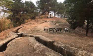
Tham Pua Cave
Tham Pua Cave is located at the foot of Pu Hong Cay limestone mountain in Ban Po area, Chieng Sinh commune, Tuan Giao district, Dien Bien province. Dien Bien Museum in conjunction with the Department of Culture, Information and Sports of Tuan Giao district inspected and surveyed Tham Pua cave and collected more than 100 relics including pebble work tools; rough almond-shaped chopping tool with rough chisel on one end; Labor tools made of stream snail shells and traces of charcoal and ash. The archaeological relics discovered in Tham Pua cave have many points very similar to the relics unearthed in Tham Khuong cave and the rocky mountains with Tham Pua cave. All of these artifacts have great historical significance, proving that this is the place of residence of ancient Vietnamese people since ancient times and this land is always associated with the history of existence and development as well as the history of Vietnam. The history of the struggle to build and defend the country of the Vietnamese people. That's why Tham Pua cave is truly a historical and cultural relic of immense value in Dien Bien. During the resistance war against the French colonialists, Tham Pua cave was chosen as the location for the first Command Post of the Tran Dinh Campaign (alias of the Dien Bien Phu Campaign) led by General Vo Nguyen Giap as Commander-in-Chief. (from December 17, 1953 to January 17, 1954). Here, from the early days of January 1954, combat orders were disseminated on a large sand table. The location of Tham Pua cave was chosen as the Command Post with a safe terrain. Next to the cave is a flat land, more than 10 hectares wide, convenient for directing campaigns in mountainous areas. Near the day of opening fire to attack the Dien Bien Phu stronghold group, the command post from Tham Pua cave was moved to Huoi He cave at km 62 near Na Tau village. Tham Pua Cave, the location of the first Command Post in Chieng Sinh, Tuan Giao and Huoi He Cave in Na Tau, Dien Bien District, where an important moment was witnessed in the decision to change the motto "fight quickly". "Quick victory" became the motto "Strong fight, steady advance" of the Dien Bien Phu Campaign Command, headed by General Commander Vo Nguyen Giap, which has become one of the prominent relics of the battlefield relics cluster. Dien Bien Phu. Source: Dien Bien Phu Historical Victory Museum
Dien Bien
6912 view
Rating : National monument