Relic point Vietnam
Việt Nam
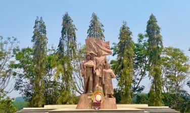
End point of petroleum pipeline VK96
Ho Chi Minh Road - a bridge connecting the great northern rear with the great southern front line, was a solid base of the southern Indochina battlefield in the resistance war against America. As we know, during the resistance war against the US, petroleum fuel was an urgent requirement to serve the large-scale and speedy war. Binh Phuoc, the land of "the hard-working but heroic East", is very honored and proud when in the province there are two relics belonging to the special relic system of Truong Son - Ho Chi Minh trail, the relics of Petrol Tank - VK98 fuel depot and VK96 petroleum pipeline terminus. Through extremely arduous years, despite terrain conditions, harsh weather and fierce enemy attacks, after 6 years (from 1968 to 1974), Truong Son pipeline soldiers has built, protected and operated smoothly a 5,000km long petroleum pipeline and a petroleum storage system of nearly 30,000 tons from the northern border of the country across Truong Son to Bu Gia Map. Bu Gia Map is the final point of the North-South petroleum pipeline. From here, the petroleum source is transported by tanker truck (completely secret) to the gasoline tanks - VK98 and VK99 fuel warehouses in Loc Ninh. The VK96 petroleum pipeline end point relic also has other names such as: symbols K22, O30. Later, he used the codename VK. The end point of this petroleum pipeline system is VK96, followed by the gasoline tanks in Loc Ninh are VK98 (Loc Quang), VK99 (Loc Hoa). The relic is the place that marks the great and silent victories of the soldiers, petrol soldiers, youth shock troops, local soldiers and civilians... during the years of resistance against the US to save the country of our nation. is a testament to one of the legends of the historic Truong Son road, which is the Truong Son petroleum pipeline system, one of the miracles of Group 559. This is one of the three main systems of the road. undermine Ho Chi Minh's strategy, demonstrating the tenacious spirit and iron will of our army and people in the resistance war against America to save the country. The victory of the resistance war against America to save the country is the victory of Vietnamese revolutionary heroism. In particular, the petroleum pipeline system - Truong Son road is the embodiment of iron will, expressing the will to win, courage, desire for independence, determination to liberate the South, and recover the mountains and rivers. about a bond of the entire Party, entire army and entire people, a shining symbol of the faithful fighting solidarity between the three countries of Vietnam - Laos - Cambodia. Truong Son route has existed in the history of the resistance war against the US to save the country as a legend with the name "Ho Chi Minh Trail". The system of petroleum pipelines - Truong Son road, the road connecting South - North associated with many heroic victories of the entire nation during the years of resistance war is forever a source of great pride, encouragement and encouragement. members of our entire army and people in the work of building and protecting our Fatherland today. With such great historical significance, the VK98 Gasoline Tank - Fuel Warehouse relic in Loc Ninh district and the VK96 petroleum pipeline end point relic in Bu Gia Map district, Binh Phuoc province are located in the Truong Son - Binh Phuoc province relic system. Ho Chi Minh Trail was recognized by the Prime Minister as a special national monument on December 9, 2013. Source: Binh Phuoc Province Electronic Information Portal
Dong Nai
4773 view
Rating : Special national monument

Historical relic of Bu Prang Border Guard Station area
On January 4, 2023, the Bu P'rang Border Guard Station area historical relic located in Dak Huyt and Bu P'rang 2 bon, Quang Truc commune, Tuy Duc district, Dak Nong province was recognized as a Monument. Provincial history. Martyrs' Memorial - a place to register and pay tribute to 16 officers and soldiers of the unit who heroically sacrificed their lives in the war to protect the Southwest border in 1977. To serve the task of protecting border security and sovereignty, on May 20, 1975, Bu P'rang People's Armed Police Station (predecessor of Bu P'rang Border Gate Border Guard Station) was established. with an initial force of 32 armed police officers and soldiers sent as reinforcements from Son La province. At that time, the station was assigned the task of managing and protecting national border security and sovereignty with a 16.5 km long border section, located in Quang Truc commune (Dak R'lap district, former Dak Lak province), now known as Dak Lak. Tuy Duc district (Dak Nong), bordering Mondulkiri province, Kingdom of Cambodia. During the war to protect the Southwest border, officers and soldiers stubbornly held on, courageously fought 127 battles, firmly defending every inch of the Fatherland's sacred land. The historical milestone that demonstrated the brave spirit of the soldiers at that time was the battle that lasted 47 days and nights (from March 29 to May 16, 1978) with the Pol Pot gang. The above mentioned victorious fight to protect border security and sovereignty demonstrated the solidarity, determination to fight and willingness to sacrifice of the officers and soldiers of the Bu P'rang People's Armed Police Station. . With that feat, on November 6, 1978, Bu P'ran People's Armed Police Station was honored by the State as Hero of the People's Armed Forces. Bu P'rang Border Gate Border Guard Station is stationed in Tuy Duc district, 35 km from the district center, assigned to manage and protect the 11 km border area, in charge of Bu P'rang 2 border. belongs to Quang Truc commune (Tuy Duc). With the spirit of "The station is home, the border is the homeland, people of all ethnic groups are blood brothers", the party committee and unit commanders have thoroughly grasped and seriously implemented the directives, orders and superiors' plans on tasks and border guard work. Accordingly, along with fully developing combat documents, the station regularly organizes training plans to ensure high combat readiness, proactively detect and promptly handle all situations that arise on the border. border, area, border station. In just the two years 2020-2021, the station organized 676 border patrols, controls and protections with 6,084 officers and soldiers, thereby detecting and handling 10 cases/11 border violators. gender. As a border gate station, the unit maintains strict and lawful immigration and import and export control activities through the border gate, and at the same time advises the Party Committee and local authorities to well carry out people-to-people diplomacy work. , maintain stability and develop cooperative relations on both sides of the border. Source: New Rural Information Website - Dak Nong Province
Lam Dong
5039 view
Rating : Provincial level relics

Serepok Bridge
Serepok bridge was built by the French in 1941, completed, put into use in 1957 and named bridge 14 by the French government (bridge located on route 14), while local people named it Serepok bridge because spanning the Serepok River connecting the two provinces of Dak Lak and Dak Nong. The eastern bridgehead belongs to Hoa Phu commune, Buon Ma Thuot city, Dak Lak province; The eastern bridgehead belongs to Tam Thang commune, Cu Jut district, Dak Nong province. In 1904, the French colonialists began building a governing apparatus, establishing an administrative unit of Dak Lak province and dividing the Dak Lak plateau into five districts. During the invasion, the French colonialists realized the difficulty of traveling on the vital road, affecting their intention to invade and expand their territory. In 1941, the French colonial government decided to build bridge 14 and the bridge was built with the blood of political prisoners in Buon Ma Thuot exile house and local people. The bridge is designed with a continuous reinforced concrete truss structure running underneath, 169.5 m long, 4 spans, 5 m wide, two pedestrian lanes of 1.37 m, vehicle lanes of 2, 8 m, load capacity 5 tons. In the early 40s of the 20th century, Serepok bridge was modern and had beautiful architecture. Entering the period 1954-1975, Route 14 was thoroughly exploited by the US imperialists and the puppet government, with blocking forces deployed to control and block all resources of the Vietnamese army. It was also here that our army and people launched an important offensive to liberate Buon Ma Thuot (Dak Lak) and then towards Saigon, completely liberating the South and reunifying the country. In 1985, facing the development of road transport, the Serepok bridge built during the French period could no longer meet the transport needs in terms of both load and vehicle density, so the Ministry of Transport decided to invest in Investing in the construction of a new bridge to replace the old bridge that has a small load and has deteriorated. The new Serepok bridge was built on Highway 14, 30 meters north of the old bridge. The bridge is 176 m long, has a simple beam reinforced concrete structure, includes 5 spans, 11 m wide, has 2 motor vehicle lanes 7 m wide and 2 walking lanes 1.25 m wide each. The project is invested by Road Zone 5 and constructed by Traffic Construction Company 510 of Transport Construction Corporation 5 under the Ministry of Transport. The bridge was completed and put into use in October 1992. Since then, vehicles traveling on Highway 14 have crossed the new bridge. In 2016, a third bridge between the two bridges was also completed to serve the increasing travel demand on Highway 14. With that meaning, Serepok Bridge was chosen by the People's Committee of Dak Nong province as a heritage site of Dak Nong Geopark under the "Symphony of the New Wind" tourist route. Source: Dak Nong Electronic Newspaper
Lam Dong
5014 view
Rating : National monument
Victory location Hill 722 - Dak Sak
Hill 722 - Dak Sak is a US-Puppet commando base established in 1965. This is where a fierce battle took place between regular troops and local military forces attacking and destroying the commando base on September 19. August 22 and 23, 1968. Hill 722 is at an altitude of 722m above sea level in Tho Hoang 4 village, Dak Sak commune, Dak Mil district. In May 1965, the US - puppet government and the Saigon government built the Hill 722 military base (also known as Duc Lap special forces camp) about 10 km east of the center of Duc Lap district to strengthen their forces. volume and increased military activities. To deal with the enemy's plots and tricks, in 1968 the Politburo and Central Highlands Field Command determined it was necessary to destroy the enemy at Duc Lap district headquarters, whose core was the military base Hill 722 - Dak Sak, one of the enemy's key strongholds on the Central Highlands front. Implementing that policy, during the years 1968 to 1975, our main force coordinated with the local army and people to organize many battles at this base, on the one hand to drain the enemy's vital forces, and on the other hand to defeat the enemy. destroyed the system of posts that were sabotaging the Ho Chi Minh Trail on the Southern Central Highlands battlefield. After 1968, after many heavy defeats in the Southern Central Highlands battlefield, the enemy retreated and entrenched in military bases, in which Hill 722 - Dak Sak was an important military base. From here, they continued to implement the policy of gathering people to form hamlets. Faced with that situation, to maintain the posture, the Quang Duc Provincial Party Committee directed the Dak Mil District Party Committee, determined to overcome difficulties, implement the "three clings" (cadres cling to the people, people cling to the land and guerrillas cling to the enemy). continue to fight the enemy, promote the construction of rear bases, increase production, and ensure food supply for the front; Expand the liberated area, push the enemy into a clustered position, and prepare to fight with the people of the whole country. By 1975, Dak Sak and Duc Lap strongholds were completely wiped out by our troops. After the liberation day, to commemorate the great sacrifice of our officers and soldiers at Hill 722 - Dak Sak in particular, and in the Duc Lap campaign in the fall of 1968 in general, Dak Nong province established a memorial to them. heroic martyrs. On October 24, 2012, Hill 722 relic - Dak Sak was recognized by the Ministry of Culture, Sports and Tourism as a national historical relic. Currently, Hill 722 - Dak Sak Historical Site has a total area of nearly 4 hectares. On this site, there are still some relics and military equipment, such as shoes, hats, and bullet casings. In 2010, Area I of the monument was invested by the State to build a memorial stele house, green campus and fence with a total construction investment area of 2,485m2. Every year, the relic serves over 1,000 visitors to visit and study. This is a historical relic of great significance in traditional education, political awareness for the young generation, and gratitude for the great contributions of our ancestors. It is one of the historical milestones in the struggle for national liberation of the Party Committee and People of Dak Nong province in particular and Vietnam in general. Source: Dak Nong Electronic Newspaper
Lam Dong
4796 view
Rating : National monument
Historical relic N'Trang Guh memorial site
Based on local historical records and the accounts of some village elders in Krong No, N'Trang Guh, real name Y Guh, is an Ede ethnic person, born around 1845, in Choáh Kplang village, now in the commune. Buon Choáh (Krong No). Legend has it that N'Trang Guh was talented, virtuous and a good hunter in the village, so he had many valuable possessions such as rhino horn and ivory. Not only that, he also knows how to calculate business well, so every time the season comes, he always harvests a lot of rice and corn, raises many buffaloes, cows, pigs, chickens... and has a reputation in near and far villages, and is loved by everyone. beloved person. In addition to being rich in wealth, he is also a compassionate person because he always guides people through experiences in hunting, animal husbandry, and farming and is willing to help the poor, in need, and with crop failures. In 1884, the Siamese army waged a war of invasion, capturing the lower reaches of the Krong No and Krong Ana rivers. Responding to N'Trang Guh's call, people in 20 Bih ethnic villages living in the Krong No and Krong Ana river basins stood up against foreign invaders. The insurgent army commanded by N'Trang Guh had up to 600 people, had no guns, only used rudimentary weapons: bows, arrows, spears... In order to increase their strength, N'Trang Guh created a fairly good crossbow. special, not found anywhere else. The crossbow is longer than a person's head, the side is one hand wide, and shoots 3 arrows at a time. With this powerful weapon, combined with the spirit of courage, tenacity and cunning, in 1887, the N'Trang Guh insurgent army surrounded and destroyed the entire Siamese army right on the fields of Tur and Phok villages. The glorious victory of the N'Trang Guh insurgent army crushed the invasion of the Siamese army, helping the people feel secure in working in production and building villages. In the early years of the 20th century, the ruling apparatus of the French colonial government acquired and controlled almost all the trading and trading of indigenous people in the Central Highlands. Bourgeois, the first French envoy in Dak Lak, blatantly used military force to drive the Ede and M'nong people to other places, taking over villages, villages, land, fields, and water wharves to Establish plantations and build a system of posts. The compatriots were forced to work as laborers on French plantations, and they had to work 14 to 15 hours a day. In early 1900, the French army invaded the villages of the Bih people along the Krong No and Krong Ana river basins. N'Trang Guh led the insurgent army to fight against the invaders, the most famous being the battle to destroy the Tur garrison. One morning in 1901, under the direction of N'Trang Guh, the insurgents crossed the Krong No River to surround Tur station, used crossbows to shoot many enemy soldiers, and then attacked the station. In just a short time, all the enemy troops stationed here were destroyed. The colonialist Buoc Gioa, who had a lot of blood debt to the people, died in front of the station yard. Taking advantage of the victory, the insurgents continued to attack, one by one destroying other colonial posts such as Jiang post, Dur post... With the skillful and courageous leadership of N'Trang Guh, the insurgents fought fought for 13 years. In 1914, because there was a traitor in the ranks of the insurgent army, the location of N'Trang Guh's station was revealed, so he was arrested by the French and sentenced to death. After N'Trang Guh passed away, his body was brought back by the people to be buried in his hometown, where he was born, Choah village, Choah village (Krong No). To remember the place that left many illustrious marks of the chief of Ede village, a hero of the Central Highlands peoples, on August 2, 2011, the Ministry of Culture, Sports and Tourism ranked N'Trang Guh souvenir site is classified as a national historical site. Source: Krong No District Electronic Information Page
Lam Dong
5047 view
Rating : National monument
The historical site connects the Central Highlands to the Southeast
The historical relic of Cay Xoai village is a contact point to open the North-South strategic corridor, the section through Dak Nong province. On May 25, 1959, the Central Military Commission and the Ministry of National Defense officially established Group B90, with the mission of secretly going to the South with on-site units to build facilities and open two routes to the East and West. from the Southern Central Highlands to the Southeast region - where the Southern Party Committee is located. Overcoming difficulties, sacrifices and even unsuccessful connection trips, finally, at about 4:00 p.m., October 30, 1960, the B90 Working Group made contact with the C200 working group of the Southeast region. Ministry at Cay Xoai village, Dak Nia commune, City. Gia Nghia, Dak Nong province. On November 4, 1960, at kilometer 4 on the Dak Song to Gia Nghia road, the western wing of Group B90 continued to make contact with unit C270 from the Southeast. This is an event of particularly important strategic significance. The North-South strategic corridor was opened, becoming an important node to help smooth the Ho Chi Minh route, from here, the transport route Military strategy Ho Chi Minh Road is like a lifeline running from North to South, providing timely human and material resources from the great rear of the socialist North to the great front line of the South, making a decisive contribution to victory. greatness of the resistance war against the US to save the country. From 1961 to 1965, the Ho Chi Minh Trail was smooth, and tens of thousands of Southern compatriots gathered to go to the North and returned to the battlefield; A series of essential items such as parcels, official documents, weapons, ammunition, including liberation radio equipment... were urgently transported by soldiers between the East and West wings. provide support for the battlefields of the South and the extreme South Central region; Transporting high-ranking Party officials to the South to lead the masses in the fight against America. After a period of operation, the base in the Southern Central Highlands was expanded and connected to areas with bases in Tay Khanh Hoa, Tay Ninh Thuan, Dak Lak, Lam Dong and connected from Dak Mil to war zone D. In addition, the Quang Duc corridor force coordinated with Cambodia to expand the control area along the corridor, creating effective continuity and coordination across battlefields during the resistance war. To achieve the miracle of connecting the battlefields, making an important contribution to the great victory of the resistance war against the US, it is impossible not to mention the role of ethnic people in the area who sacrificed their lives, arduously protecting the corridor, protecting forces participating in military transport on Truong Son road, hiding officers, protecting the revolution, ensuring smooth operations. These are the boys and girls of Group H50 who stick to the road, despite hardships and deprivation; They are groups of local civilians who secretly carry goods and weapons to overcome high passes, steep slopes, muddy fields and dangerous posts; That is the image of 800 compatriots at Nam Nung base having to eat forest leaves and tubers to save rice, corn, potatoes, and cassava to help the road construction team and officers and soldiers walking on the corridor, despite the dangers to get there. raise troops, protect revolutionary soldiers... Cay Xoai village historical relic "Place to establish communication to open the North-South strategic corridor, section through Dak Nong province" is one of the historical places associated with the miracle of the 20th century - Duong Truong Son, invested in construction by the State and completed on March 23, 2010. On August 2, 2011, the Ministry of Culture, Sports and Tourism recognized this as a national revolutionary historical relic. On October 30, 2017, the People's Committee of Dak Nong province organized a memorial ceremony and placed a stele listing the list of officers and soldiers who participated in fighting and sacrificed their lives in carrying out the tasks of construction and protection. North-South strategic corridor, in Cay Xoai village, Dak Nia commune, City. Gia Nghia, Dak Nong province. Source: Party Committee of Agencies and Enterprises of Dak Nong Province
Lam Dong
9415 view
Rating : National monument

Relics of N'Trang Long's anti-French colonial movement
The locations of the Mnong people's movement against the French colonialists led by the hero N'Trang Long are places that mark glorious and heroic victories against foreign invaders, demonstrating the will to fight resiliently. the indomitable spirit, solidarity, and gratitude of the people of the Central Highlands ethnic groups in the national liberation struggle movement. After the war passed, this place still has traces of tunnels, trenches, ramparts, fortifications... with historical and cultural value in educating generations about the tradition of love for the homeland. Currently, to remember the merits and victories of the struggle against the invaders, the authorities have ranked, invested in, renovated, and restored a number of locations of the struggle movement led by N'Trang Long in Tuy Duc district and building a monument in Gia Nghia City specifically as: 1. The remains of Bu Méra post have a total area of 1 hectare (100m - 100m). The previous post was arranged quite scientifically, including a main door in the West - North, 2.5m wide and 2 side doors (exit doors). dangerous) West - South and East - North through the trench running down the Dak Buk So tributary. With an overall area of only 1 hectare, Bu Méra station contains an ecological sub-population with echoes of the Central Highlands mountains and forests; There are many types of large wood, aged from 70 to 90 years (regenerated wood, still almost intact), along with many species of birds, squirrels, reptiles, etc. Currently, the relic has been restored and embellished. with items such as moats, ramparts, gates, etc. to serve tourists. 2. Bu Nor bon vestiges with an area of about 7 hectares, currently located in the protective forest of Quang Tan Forestry Enterprise with many types of wood of quite large size, still intact. 3. The vestiges of "Henri Maitre Beer" were recognized as a provincial historical relic by the People's Committee of Dak Nong province on December 24, 2008 by the People's Committee of Dak Nong province. Currently, Henri Maitre's grave remains intact. The grave has an area of about 3m2, the highest point is 40cm (above the ground), traces reflect the crimes of the French colonialists against the people of the Central Highlands ethnic groups; reflects the resilient and indomitable will to fight of the people of Dak Nong ethnic groups under the brave strategic leadership of national hero N'Trang Long. 4. Monument to Hero N'Trang Long and the national liberation movement of 1912 - 1935 at Dak Nu hill, Nghia Duc ward, Gia Nghia city. On August 27, 2007, the historical site of the anti-French colonial movement of the M'nong people led by N'Trang Long was recognized as a national revolutionary historical site. according to the decision of the Ministry of Culture, Sports and Tourism. Source: Department of Culture, Sports and Tourism of Dak Nong
Lam Dong
5052 view
Rating : National monument
Revolutionary historical relics B4 Resistance Base - Interprovince IV
The B4 - Interprovincial IV resistance base relic area in Tan Tien village, Nam Nung commune (Krong No) is currently being invested in construction and restoration, nearly completed. Not only is it a "red address" to preserve and educate revolutionary traditions, but the relic site promises to become one of the attractive historical-ecological tourist destinations. The historical relic of resistance base B4 - Inter-Province IV is located in the middle of a rolling hilly area that seems to embrace and protect the vestiges of a heroic historical period. Here, in December 1960, the Quang Duc Provincial Party Committee was established under the 5th Inter-Regional Party Committee, based on the resistance base area in Nam Nung including the villages of R'cop, Ja Ráh, Doc Ju, Broah, Choaih, Fi Bri to lead the revolution. Resistance Base Area B4 - Inter-Province IV during the resistance war played the role of both the front line and the rear, a place to build revolutionary forces and participate in producing and supplying food for the front line, for other regions to relieve hunger. At the same time, it is also the place to organize major battles right in the base area, draining enemy forces, opening up strategic corridors, and effectively serving the Southern battlefield. With those heroic historical achievements, on March 17, 2005, the Ministry of Culture, Sports and Tourism recognized the B4 Resistance Base - Inter-Province IV Historical Relic as a National-level relic. In order for the place to be worthy of its role and position in revolutionary history, in recent years, the Provincial Department of Culture, Sports and Tourism has organized surveys and zoned relics. On that basis, the province also decided to invest more than 28 billion VND to build and restore items: fortification area, inter-provincial office area IV, B4 Personnel Office office, conference hall, military station. y, bridge over the base area, internal roads of the base area, ceremonial areas (souvenir houses, memorial stele, monuments) and planting trees, creating environmental landscape in the Nam Nung revolutionary base area. In order to promote the value of revolutionary history, propaganda and education work among the people, especially the young generation, about the great value of the relic site has been widely deployed, since then, there has been a conscious Protect and understand the cultural and historical tourism potential of the homeland. Source: Dak Nong Electronic Newspaper
Lam Dong
5283 view
Rating : National monument
Dak Mil Prison
Located along Highway 14, about 60 km from the center of Gia Nghia town, Dak Mil prison, located in Dak Mil district, is a majestic historical relic still bearing the mark of time. Dak Mil Prison, recognized as a National Historical Site on March 17, 2005. In 1940, the Revolutionary movement broke out all over the country, due to the increasing number of political prisoners at Buon Ma Thuot Prison and to serve the construction of the road through the M'Nong plateau next to Buon prison. Ma Thuot French colonialists also built Dak Mil Prison, (now in Dak Mil district, Dak Nong) in the middle of an old forest, where the sacred forest and poisonous water were used to imprison political prisoners. Dak Mil Prison, became a revolutionary base in the district and witnessed many escapes by Vietnamese Communist soldiers. From 1940 to 1943, this place detained hundreds of communist soldiers, at one time up to 120 people. Revolutionary soldiers exiled to Dak Mil Prison, from 1941 to 1943: Chu Hue, Ho Tung Mau, Nguyen Tao, Tran Huu Doanh, Truong Van Linh, Nguyen Khai, Tran Tong, Le Nam Thang... At the end of 1943, the French transferred all the prisoners here to Buon Ma Thuot prison and destroyed Dak Mil prison. Dak Mil Prison, in ancient times, was built on a piece of land in the middle of the gloomy mountains and forests of Dak Mil district. Outside the 9-room wooden prison with a thatched roof is a wooden fence secured with barbed wire. Inside the Prison, the walkway is located between two rows of wooden floors with enough foot shackles and hand shackles, each shackle has 4 bamboo pipes hanging: 2 upper pipes for drinking water, 2 lower pipes for urine and feces. Over a long period of time, Dak Mil Prison was dilapidated and became ruins. Currently, on December 31, 2010, after more than two years of restoration, Dak Nong province completed the restoration and construction of the Dak Mil Prison National Historical Site, in village 9A, Dak Lao commune. (Dak Mil). The project is invested by the Ministry of Culture, Sports and Tourism with a total cost of over 9 billion VND. The entire relic is located in the middle of a crowded residential area with an area of nearly 1 hectare, with two main items: the prison and the exhibition house of artifacts. The prison has been recreated with an area similar to the prison previously built by the French colonialists, and the old foundations still remain. Source: Dak Mil District Electronic Information Page,.
Lam Dong
7123 view
Rating : National monument
Co Thach Pagoda
Co Thach Pagoda (also known as Co Thach Pagoda, or Hang Pagoda) is located in Binh Thanh commune, Tuy Phong district (Binh Thuan), in the Co Thach beach area With unique architecture in an amazing natural landscape, Co Thach Pagoda has been recognized as a national monument and landscape of Vietnam. From the years 1835-1836, Zen master Bao Tang came to Binh Thanh to establish Co Thach Pagoda and stayed here for five years. After that, the Zen master entrusted the pagoda to his disciples to take care of. He continued to travel alone to the South of the country and stopped in the Southeast region (Dong Nai and Ba Ria - Vung Tau). Initially, the pagoda was just a small hut with plank walls and thatched roofing. Through many restorations and embellishments, during the Thieu Tri period, the pagoda was built to be large in both space and art and remains almost intact to this day. . Up to now, even though it has been 170 years, the pagoda still preserves many Han Nom cultural heritage; tureen; opposite to; horizontal panels and many precious ancient documents. Among them, Dai Hong Chung and thunder drums have been dated to the early 19th century. Co Thach Pagoda area is an architectural complex, temple, temple, and cup connected together on a rocky hill area of more than 4 hectares. In early 1997, the pagoda built more statues of Guanyin Buddha scattered along the coast, creating a beautiful scenery when looking down from the pagoda. The path to Tam Quan gate consists of 36 steps mounted with stone slabs. At the foot of the stairs are a pair of dragons winding on both sides. To the right of the bridge at the gate is a statue of a sitting tiger and symmetrically is a statue of a lying elephant with sophisticated sculpting techniques. The main hall of the pagoda is located in a natural rocky mountain complex, sometimes nestled between large rocks. Next are the meditation houses, temples, ancestral houses, bell towers, empty floors, and worshiping huts, with quite impressive and well-preserved tureens and horizontal panels. Many Han Nom cultural heritages, tureens, lanterns, horizontal panels and documents date back to the pagoda's founding. Some antiques have cultural and historical value. Each cave worships a Buddha, a Bodhisattva, or a monk who has passed away. Three natural stone slabs are arranged in a horizontal row in front of the main hall in the shape of an orca (according to Buddha's scriptures, called a "ghost", a sea monster considered an incarnation of Bodhisattva Avalokiteśvara to help the Buddha). help fishermen when in trouble at sea). The temple follows an ancient architectural style so it is decorated with many eye-catching colors. Because the terrain is a high rocky mountain, each path of the temple has gentle steps up and down along the slope. Right at the foot of the pagoda is a vast ocean, creating a charming landscape. Co Thach Pagoda is located on a rocky mountain complex, so it also has many special caves. Taking advantage of this terrain, Zen masters used them as places of worship. Each cave in Co Thach Pagoda worships a Buddha, Bodhisattva or a monk who has passed away. Here, there is a cave of the Patriarch - the person who built this pagoda. Outside the statue worshiping the Patriarch, there are also tablets with merits in building the pagoda. Next to that is the cave worshiping Buddha Mau Chuan De. In this cave there is an 8-armed Buddha statue and many other ancient statues. In Tam Bao cave, Zen masters used to worship 23 ancient Buddha statues of many different sizes and ages. On the 25th day of the 5th lunar month every year will be the death anniversary of Co Thach Pagoda. This is the day for monks, nuns, and Buddhists here to remember the great gratitude of Zen Master Bao Tang - who had great contributions in building the pagoda that day. Source: Online Buddhism
Lam Dong
5136 view
Rating : National monument